<?xml version="1.0" encoding="ISO-8859-1"?><article xmlns:mml="http://www.w3.org/1998/Math/MathML" xmlns:xlink="http://www.w3.org/1999/xlink" xmlns:xsi="http://www.w3.org/2001/XMLSchema-instance">
<front>
<journal-meta>
<journal-id>1562-3823</journal-id>
<journal-title><![CDATA[Revista Boliviana de Física]]></journal-title>
<abbrev-journal-title><![CDATA[Revista Boliviana de Física]]></abbrev-journal-title>
<issn>1562-3823</issn>
<publisher>
<publisher-name><![CDATA[Sociedad Boliviana de Física]]></publisher-name>
</publisher>
</journal-meta>
<article-meta>
<article-id>S1562-38232012000400017</article-id>
<title-group>
<article-title xml:lang="en"><![CDATA[Using Space-Borne Lidar to Identify Tropospheric Aerosols]]></article-title>
</title-group>
<contrib-group>
<contrib contrib-type="author">
<name>
<surname><![CDATA[Hamill]]></surname>
<given-names><![CDATA[Patrick]]></given-names>
</name>
</contrib>
<contrib contrib-type="author">
<name>
<surname><![CDATA[Lopez-Garibay]]></surname>
<given-names><![CDATA[Araceli]]></given-names>
</name>
</contrib>
</contrib-group>
<aff id="A01">
<institution><![CDATA[,USA California Department of Physics and Astronomy]]></institution>
<addr-line><![CDATA[ ]]></addr-line>
<country>USA</country>
</aff>
<pub-date pub-type="pub">
<day>00</day>
<month>00</month>
<year>2012</year>
</pub-date>
<pub-date pub-type="epub">
<day>00</day>
<month>00</month>
<year>2012</year>
</pub-date>
<volume>20</volume>
<numero>20</numero>
<fpage>48</fpage>
<lpage>50</lpage>
<copyright-statement/>
<copyright-year/>
<self-uri xlink:href="http://www.scielo.org.bo/scielo.php?script=sci_arttext&amp;pid=S1562-38232012000400017&amp;lng=en&amp;nrm=iso"></self-uri><self-uri xlink:href="http://www.scielo.org.bo/scielo.php?script=sci_abstract&amp;pid=S1562-38232012000400017&amp;lng=en&amp;nrm=iso"></self-uri><self-uri xlink:href="http://www.scielo.org.bo/scielo.php?script=sci_pdf&amp;pid=S1562-38232012000400017&amp;lng=en&amp;nrm=iso"></self-uri><abstract abstract-type="short" xml:lang="en"><p><![CDATA[An important contemporary problem is the identification of aerosols from space. Ground based lidar systems can use correlative measurements to determine aerosol types but spaceborne lidar systems (such as CALIPSO) rely on models for this identification. Most spaceborne systems (including CALIPSO, MODIS, and OMI) use models based on observations by AERONET, a world- wide network of ground based sun photometers. The aerosol parameters determined by AERONET include the real and imaginary refractive indices, the single scattering albedo and the extinction and absorption Angstrom coefficients. We compare the predictions of the satellite models with AERONET measurements by evaluating the Mahalonibis distances from the model prediction to clusters of aerosols of specific types (such as Urban-Industrial, Biomass Burning, and Dust). We show that some regions do not fit any of the traditional categories; consequently, aerosol identification is problematic. We discuss some of the difficulties associated with aerosol identification from space, specifically considering the CALIPSO system]]></p></abstract>
<kwd-group>
<kwd lng="en"><![CDATA[Aerosols]]></kwd>
<kwd lng="en"><![CDATA[Lidar]]></kwd>
<kwd lng="en"><![CDATA[Aeronet]]></kwd>
<kwd lng="en"><![CDATA[Modis]]></kwd>
<kwd lng="en"><![CDATA[Omi]]></kwd>
<kwd lng="en"><![CDATA[Calipso]]></kwd>
</kwd-group>
</article-meta>
</front><body><![CDATA[ <p align="center"><font size="4" face="Verdana"><strong>Using Space-Borne Lidar to Identify Tropospheric Aerosols</strong></font></p>     <p align="center">&nbsp;</p>     <p align="center"><strong><font size="3" face="Verdana">Patrick   Hamill and Araceli Lopez-Garibay</font></strong></p>     <p align="center"><strong><font size="2" face="Verdana">Department   of Physics and Astronomy</font></strong></p>     <p align="center"><strong><font size="2" face="Verdana">San   Jose State University</font></strong></p>     <p align="center"><strong><font size="2" face="Verdana">San   Jose, California, USA</font></strong></p>     <p align="center"><font size="2" face="Verdana"><strong>Tel:   1+408 924 5241, E-mail: patrick.hamill@sjsu.edu</strong></font></p><hr>     <p><font size="2" face="Verdana"><b>SUMMARY</b></font></p>     <p><font size="2" face="Verdana">An important contemporary problem is   the identification of aerosols from space. Ground based lidar systems can use   correlative measurements to determine aerosol types but spaceborne lidar   systems (such as CALIPSO) rely on models for this identification. Most spaceborne   systems (including CALIPSO, MODIS, and OMI) use models based on observations by   AERONET, a world- wide network of ground based sun photometers. The aerosol   parameters determined by AERONET include the real and imaginary refractive   indices, the single scattering albedo and the extinction and absorption   Angstrom coefficients. We compare the predictions of the satellite models with   AERONET measurements by evaluating the Mahalonibis distances from the model   prediction to clusters of aerosols of specific types (such as Urban-Industrial,   Biomass Burning, and Dust). We show that some regions do not fit any of the   traditional categories; consequently, aerosol identification is problematic. We   discuss some of the difficulties associated with aerosol identification from   space, specifically considering the CALIPSO system</font></p>     <p><font size="2" face="Verdana"><b>Key words: </b>Aerosols, Lidar, Aeronet, Modis, Omi, Calipso.</font></p><hr>     ]]></body>
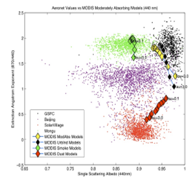
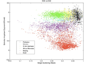
<body><![CDATA[<p><font size="2" face="Verdana"><b>STATEMENT OF THE PROBLEM</b></font></p>     <p><font size="2" face="Verdana">It is well known that tropospheric   aerosols are an important factor affecting climate change. The Intergovernmental   Panel on Climate Change (IPCC) states that the aerosol contribution to   anthropogenic climate change has a large degree of uncertainty. Consequently,   it is of particular interest to be able to give a quantitative accounting of   the amount and type of aerosols on a global basis. Only satellite borne sensors   (such as the CALIOPE lidar or the OMI or MODIS sensors) can generate the   density of measurements on a global scale that is required to understand the   role of aerosols.</font></p>     <p><font size="2" face="Verdana">In this paper we describe the   models used by three satellite groups (CALIPSO, MODIS, OMI) to identify   aerosols, and we compare the results obtained from these models with the data   obtained by AERONET. We find that in general there is a weak agreement between   models and observations, as quantified by the Mahalanobis distances from known   aerosol types.</font></p>     <p><font size="2" face="Verdana">Although it is not discussed in   this extended abstract, we have found that the degree of linear polarization (a   quantity that can be obtained from other aerosol parameters) can also be used   as a means of aerosol identification.</font></p>     <p><font size="2" face="Verdana"><b>AERONET</b></font></p>     <p><font size="2" face="Verdana">AERONET (AErosol RObotic NETwork)   is an aerosol monitoring network consisting of about 200 solar-</font></p>     <p><font size="2" face="Verdana">powered CIMEL Electronique spectral   radiometers that measure sun and sky radiances at several different wavelengths   (normally 440, 670, 870 and 1020 nm). The data obtained are inverted to give   aerosol optical depths, size distributions, and diverse optical parameters such   as refractive index, single scattering albedo and phase function at several   different wavelengths. (Holben et al., 1998)</font></p>     <p><font size="2" face="Verdana">The AERONET archive is a valuable   resource for determining properties of aerosols. Cattrall <i>et al</i>. (2005)   in a preliminary study for CALIPSO used the AERONET archive to define a number   of different types of aerosols, based on location and time of year. For   example, measurements made at the NASA Goddard Space Flight Center (GSFC)   during the period June through September were classified as “Urban Industrial”.   (We have modified the Cattrall categorization somewhat because we are using   Version 2 of the AERONET data and some of the types based on the earlier   version are not appropriate.)</font></p>     <p><font size="2" face="Verdana">In Figure 1 we show scatterplots of   extinction angstrom exponent (EAE) <i>vs. </i>single scattering albedo (SSA)   for the Aeronet data from a number of different sites characterized as   urban-industrial, biomass burning, dust, and a “mixed-industrial” category   which was observed in Mexico City and Beijing. There are two distinct types of   biomass burning aerosols, those found in Africa and those found in South America.   In this analysis we used five different parameters (single scattering albedo,   extinction angstrom exponent, absorption angstrom exponent, real index of   refraction and imaginary index of refraction) at four different wavelengths.   Plots such as Figure 1 show that different aerosol types are reasonably well   differentiated, and suggests that these parameters could be used to identify   aerosols from space.</font></p>     <p><font size="2" face="Verdana"><img width=303 height=225 id="Imagen 1" src="/img/revistas/rbf/v20n20/v20n20a17-image001.png"></font></p>     ]]></body>
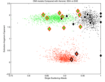
<body><![CDATA[<p><font size="2" face="Verdana"><b>MAHALANOBIS   DISTANCE</b></font></p>     <p><font size="2" face="Verdana">The Mahalanobis “distance” (which   is measured in terms of the standard deviation of a data set) is an efficient   and reasonable measure of the probability that a specific measurement belongs   to that data set. Consequently, we evaluated the Mahalanobis distances from a   set of selected measurements to the various clusters that we consider as   “canonical” aerosol types, namely, Urban-Industrial, Biomass-South America,   Biomass-Africa, Dust, and Mixed-Industrial. We determined which cluster is   “closest” to the selected measurement and as long as it is less than 3 standard   deviations from the cluster, we assume the aerosol is of that type.</font></p>     <p><font size="2" face="Verdana">The Mahalanobis distance can be   evaluated using any number of parameters. We normally used five parameters at a   single wavelength, but we have carried out calculations using 26 parameters,   including values from four different wavelengths. The results are not   significantly different from what is presented here.</font></p>     <p><font size="2" face="Verdana">The Mahalanobis distance is defined   as follows: Let <b>x</b>=(x1,x2,…,xN)T be an N dimensional vector representing the values of   N parameters for a “test point” x. Consider a cluster of values with means   given by the vector <b>m</b>=(m1,m2,…,mN)T. The Mahalanobis distance from the test point to the   cluster is <img width=155 height=28 id="Imagen 2" src="/img/revistas/rbf/v20n20/v20n20a17-image002.png">Where S=cov(<i>xi,xj) </i>is the covariance matrix whose elements are defined by   S=E[(<b>x-m</b>)(<b>x-m</b>)T]. Here E is the “expectation” which in our case is   just the mean value.</font></p>     <p><font size="2" face="Verdana"><b>THE   SATELLITE MODELS</b></font></p>     <p><font size="2" face="Verdana">MODIS, OMI and CALIPSO scientists   identify aerosol types based on models involving parameters obtained from their   measurements. These differ for different sensors. For example, the CALIPSO   instrument measures backscatter whereas MODIS and OMI are spectral radiometers.   It should be kept in mind that these instruments are extremely good at carrying   out their principle tasks; the identification of tropospheric aerosols is not   their main purpose. Nevertheless, it is of interest to determine how well one   can determine aerosol type from satellite data, so we have carried out an   analysis of the models used by the three satellite groups to see how they   compare with the AERONET data.</font></p>     <p><font size="2" face="Verdana">The MODIS models are divided into   models for aerosols observed over land and aerosols observed over oceans. We   only used AERONET data from land based photometers, so we present here the   MODIS land models for comparison with AERONET retrieved quantities. The   parameters used in the MODIS models were taken from the MODIS ATBD (Remer,   2004). These parameters (indices of refraction, mode radius, standard   deviation, etc.) are presented as functions of the optical depth. In the   figures, the nine heavy diamonds represent MODIS model results for optical   depths ranging from 0.1 to 5.0 for dust and to 3.0 for other models. For   example, in the EAE <i>vs. </i>SSA plot, the dust models are represented by red   diamonds for t ranging from t= 0.1 (at the lower end of the red diamonds) to t = 5 (at the   upper end).</font></p>     <p><font size="2" face="Verdana">The parameters for our evaluations   of the OMI models are taken from the OMI ATBD and Curier (2008). The OMI models   do not include variations in size distribution or index of refraction with   wavelength except for desert dust. As shown in the plots below, the agreement   between OMI models and AERONET retrieved values is reasonable. We did not use   all the OMI dust models, only those assuming spherical particles. The imaginary   indices of refraction used in our calculations for dust were obtained by a   large extrapolation from the UV values of Colarco (2002) and of Sinyuk (2002).</font></p>     <p><font size="2" face="Verdana"><img width=279 height=260 id="Imagen 3" src="/img/revistas/rbf/v20n20/v20n20a17-image003.png"></font></p>     <p><font size="2" face="Verdana">Figure 2. EAE <i>vs</i>. SSA for   four characteristic aerosol types compared to MODIS models</font></p>     ]]></body>

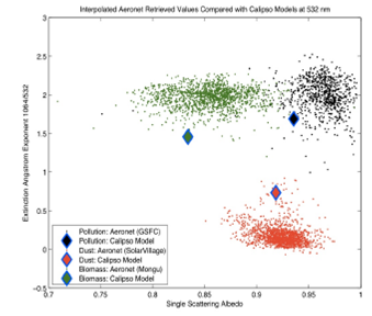
<body><![CDATA[<p><font size="2" face="Verdana"><img width=339 height=266 id="Imagen 4" src="/img/revistas/rbf/v20n20/v20n20a17-image004.png"></font></p>     <p><font size="2" face="Verdana">Figure 3. EAE <i>vs. </i>SSA for four characteristic aerosol   types compared to OMI models.</font></p>     <p><font size="2" face="Verdana">The AERONET retrieved quantities   are reported at 440, 630, 870 and 1020 nm. The CALIPSO models are for 532 and   1064 nm. Thus we can either interpolate and extrapolate the CALIPSO values to   the AERONET wavelengths, or interpolate and extrapolate the AERONET retrieved   values to the CALIPSO wavelengths. We chose to do the latter. The lack of   agreement between the models and AERONET might be a consequence of these interpolations   and extrapolations. Parameters for the CALIPSO models are from Omar (2009).</font></p>     <p><font size="2" face="Verdana"><b>CONCLUSIONS</b></font></p>     <p><font size="2" face="Verdana">The Mahalanobis distance is a   useful quantity for identifying aerosol types by determining its value from   clusters of aerosols whose type is known with some degree of certainty. Using   the Mahalanobis distance we can identify regions of parameter space for   different types of aerosols and the boundaries between one type of aerosol and   another. Our analysis demonstrated that Mexico City and Beijing aerosols are not   similar to the Urban Industrial aerosols of Eastern USA and France. Mexico City   and Beijing aerosols have properties lying between biomass burning and dust.   Models used to identify aerosols from MODIS, CALIPSO and OMI are not always   nearest (in terms of Mahalanobis distance) to the aerosol types they represent.</font></p>     <p><font size="2" face="Verdana">The Mahalanobis distances for the   various satellite models compared to the aeronet clusters are given in the   following tables.</font></p>     <p><font size="2" face="Verdana"><img width=339 height=288 id="Imagen 5" src="/img/revistas/rbf/v20n20/v20n20a17-image005.png"></font></p>     <p><font size="2" face="Verdana">Figure 4. EAE <i>vs. </i>SSA for   four characteristic aerosol types compared to CALIPSO models.</font></p>     <p><font size="2" face="Verdana"><img width=375 height=320 id="Imagen 6" src="/img/revistas/rbf/v20n20/v20n20a17-image006.png"></font></p>     <p><font size="2" face="Verdana"><b>REFERENCES</b></font></p>     ]]></body>
<body><![CDATA[<!-- ref --><p><font size="2" face="Verdana">1.- C. Cattrall <i>et al., </i>J.   Geophys.Res., doi:10.1029/2004 JD005124, 2005.</font>&nbsp;&nbsp;&nbsp;&nbsp;&nbsp;&nbsp;&nbsp;&nbsp;[&#160;<a href="javascript:void(0);" onclick="javascript: window.open('/scielo.php?script=sci_nlinks&ref=229764&pid=S1562-3823201200040001700001&lng=','','width=640,height=500,resizable=yes,scrollbars=1,menubar=yes,');">Links</a>&#160;]<!-- end-ref --><!-- ref --><p><font size="2" face="Verdana">2.- P. R. Colarco, O. B. Toon, O.   Torres and P. Rasch, J. Geophys. Res., doi:10.1029/2001JK000903, 2002.</font>&nbsp;&nbsp;&nbsp;&nbsp;&nbsp;&nbsp;&nbsp;&nbsp;[&#160;<a href="javascript:void(0);" onclick="javascript: window.open('/scielo.php?script=sci_nlinks&ref=229765&pid=S1562-3823201200040001700002&lng=','','width=640,height=500,resizable=yes,scrollbars=1,menubar=yes,');">Links</a>&#160;]<!-- end-ref --><!-- ref --><p><font size="2" face="Verdana">3.- R. L. Currier <i>et al</i>., J.   Geophys. Res., doi:10.1029/ 2007JD008738, 2008.</font>&nbsp;&nbsp;&nbsp;&nbsp;&nbsp;&nbsp;&nbsp;&nbsp;[&#160;<a href="javascript:void(0);" onclick="javascript: window.open('/scielo.php?script=sci_nlinks&ref=229766&pid=S1562-3823201200040001700003&lng=','','width=640,height=500,resizable=yes,scrollbars=1,menubar=yes,');">Links</a>&#160;]<!-- end-ref --><!-- ref --><p><font size="2" face="Verdana">4.- Dubovik (2002): O. Dubovik <i>et   al</i>., J. Atmos. Sci, 59, 590, 2002.</font>&nbsp;&nbsp;&nbsp;&nbsp;&nbsp;&nbsp;&nbsp;&nbsp;[&#160;<a href="javascript:void(0);" onclick="javascript: window.open('/scielo.php?script=sci_nlinks&ref=229767&pid=S1562-3823201200040001700004&lng=','','width=640,height=500,resizable=yes,scrollbars=1,menubar=yes,');">Links</a>&#160;]<!-- end-ref --><!-- ref --><p><font size="2" face="Verdana">5.- Holben, B. <i>et al. </i>Rem.   Sens. Env. 66, 1-16, 1998. </font>&nbsp;&nbsp;&nbsp;&nbsp;&nbsp;&nbsp;&nbsp;&nbsp;[&#160;<a href="javascript:void(0);" onclick="javascript: window.open('/scielo.php?script=sci_nlinks&ref=229768&pid=S1562-3823201200040001700005&lng=','','width=640,height=500,resizable=yes,scrollbars=1,menubar=yes,');">Links</a>&#160;]<!-- end-ref --><!-- ref --><p><font size="2" face="Verdana">6.- Omar, A. <i>et al.</i>, Journal of Atmospheric and   Oceanic Technology, doi:10.1175/2009 JTECHA1231.1, 2009.</font>&nbsp;&nbsp;&nbsp;&nbsp;&nbsp;&nbsp;&nbsp;&nbsp;[&#160;<a href="javascript:void(0);" onclick="javascript: window.open('/scielo.php?script=sci_nlinks&ref=229769&pid=S1562-3823201200040001700006&lng=','','width=640,height=500,resizable=yes,scrollbars=1,menubar=yes,');">Links</a>&#160;]<!-- end-ref --><!-- ref --><p><font size="2" face="Verdana"> 7.- L. Remer, D. Tanre and   Y. Kaufman. Algorithm for Remote Sensing of Tropospheric Aerosols from MODIS.   Collection 05. Product ID MOD04/MYD04 </font>&nbsp;&nbsp;&nbsp;&nbsp;&nbsp;&nbsp;&nbsp;&nbsp;[&#160;<a href="javascript:void(0);" onclick="javascript: window.open('/scielo.php?script=sci_nlinks&ref=229770&pid=S1562-3823201200040001700007&lng=','','width=640,height=500,resizable=yes,scrollbars=1,menubar=yes,');">Links</a>&#160;]<!-- end-ref --><!-- ref --><p><font size="2" face="Verdana">8.- A. Sinyuk, O. Torres and O. Dubovik,   Geophys. Res. Lett., doi:10.1029/2002GL016189</font>&nbsp;&nbsp;&nbsp;&nbsp;&nbsp;&nbsp;&nbsp;&nbsp;[&#160;<a href="javascript:void(0);" onclick="javascript: window.open('/scielo.php?script=sci_nlinks&ref=229771&pid=S1562-3823201200040001700008&lng=','','width=640,height=500,resizable=yes,scrollbars=1,menubar=yes,');">Links</a>&#160;]<!-- end-ref --> ]]></body><back>
<ref-list>
<ref id="B1">
<label>1</label><nlm-citation citation-type="journal">
<person-group person-group-type="author">
<name>
<surname><![CDATA[Cattrall]]></surname>
<given-names><![CDATA[C.]]></given-names>
</name>
</person-group>
<source><![CDATA[J. Geophys.Res.]]></source>
<year>2005</year>
</nlm-citation>
</ref>
<ref id="B2">
<label>2</label><nlm-citation citation-type="journal">
<person-group person-group-type="author">
<name>
<surname><![CDATA[Colarco]]></surname>
<given-names><![CDATA[P. R.]]></given-names>
</name>
<name>
<surname><![CDATA[Toon]]></surname>
<given-names><![CDATA[O. B.]]></given-names>
</name>
<name>
<surname><![CDATA[Torres]]></surname>
<given-names><![CDATA[O.]]></given-names>
</name>
<name>
<surname><![CDATA[Rasch]]></surname>
<given-names><![CDATA[P.]]></given-names>
</name>
</person-group>
<source><![CDATA[J. Geophys. Res.]]></source>
<year>2002</year>
</nlm-citation>
</ref>
<ref id="B3">
<label>3</label><nlm-citation citation-type="journal">
<person-group person-group-type="author">
<name>
<surname><![CDATA[Currier]]></surname>
<given-names><![CDATA[R. L.]]></given-names>
</name>
</person-group>
<source><![CDATA[J. Geophys. Res.]]></source>
<year>2008</year>
</nlm-citation>
</ref>
<ref id="B4">
<label>4</label><nlm-citation citation-type="journal">
<person-group person-group-type="author">
<name>
<surname><![CDATA[Dubovik]]></surname>
<given-names><![CDATA[O.]]></given-names>
</name>
</person-group>
<source><![CDATA[J. Atmos. Sci]]></source>
<year>2002</year>
<volume>59</volume>
<page-range>590</page-range></nlm-citation>
</ref>
<ref id="B5">
<label>5</label><nlm-citation citation-type="journal">
<person-group person-group-type="author">
<name>
<surname><![CDATA[Holben]]></surname>
<given-names><![CDATA[B.]]></given-names>
</name>
</person-group>
<source><![CDATA[Rem. Sens. Env.]]></source>
<year>1998</year>
<volume>66</volume>
<page-range>1-16</page-range></nlm-citation>
</ref>
<ref id="B6">
<label>6</label><nlm-citation citation-type="journal">
<person-group person-group-type="author">
<name>
<surname><![CDATA[Omar]]></surname>
<given-names><![CDATA[A.]]></given-names>
</name>
</person-group>
<source><![CDATA[Journal of Atmospheric and Oceanic Technology]]></source>
<year>2009</year>
</nlm-citation>
</ref>
<ref id="B7">
<label>7</label><nlm-citation citation-type="">
<person-group person-group-type="author">
<name>
<surname><![CDATA[Remer]]></surname>
<given-names><![CDATA[L.]]></given-names>
</name>
<name>
<surname><![CDATA[Tanre]]></surname>
<given-names><![CDATA[D.]]></given-names>
</name>
<name>
<surname><![CDATA[Kaufman]]></surname>
<given-names><![CDATA[Y.]]></given-names>
</name>
</person-group>
<article-title xml:lang="en"><![CDATA[Algorithm for Remote Sensing of Tropospheric Aerosols from MODIS]]></article-title>
<source><![CDATA[Collection 05: Product ID]]></source>
<year></year>
</nlm-citation>
</ref>
<ref id="B8">
<label>8</label><nlm-citation citation-type="journal">
<person-group person-group-type="author">
<name>
<surname><![CDATA[Sinyuk]]></surname>
<given-names><![CDATA[A.]]></given-names>
</name>
<name>
<surname><![CDATA[Torres]]></surname>
<given-names><![CDATA[O.]]></given-names>
</name>
<name>
<surname><![CDATA[Dubovik]]></surname>
<given-names><![CDATA[O.]]></given-names>
</name>
</person-group>
<source><![CDATA[Geophys. Res. Lett.]]></source>
<year></year>
</nlm-citation>
</ref>
</ref-list>
</back>
</article>