<?xml version="1.0" encoding="ISO-8859-1"?><article xmlns:mml="http://www.w3.org/1998/Math/MathML" xmlns:xlink="http://www.w3.org/1999/xlink" xmlns:xsi="http://www.w3.org/2001/XMLSchema-instance">
<front>
<journal-meta>
<journal-id>1562-3823</journal-id>
<journal-title><![CDATA[Revista Boliviana de Física]]></journal-title>
<abbrev-journal-title><![CDATA[Revista Boliviana de Física]]></abbrev-journal-title>
<issn>1562-3823</issn>
<publisher>
<publisher-name><![CDATA[Sociedad Boliviana de Física]]></publisher-name>
</publisher>
</journal-meta>
<article-meta>
<article-id>S1562-38232012000400007</article-id>
<title-group>
<article-title xml:lang="en"><![CDATA[Evaluation of inversion algorithm sensitivity in stratospheric ozone DIAL profile.]]></article-title>
</title-group>
<contrib-group>
<contrib contrib-type="author">
<name>
<surname><![CDATA[Orte]]></surname>
<given-names><![CDATA[F.]]></given-names>
</name>
</contrib>
<contrib contrib-type="author">
<name>
<surname><![CDATA[Wolfram]]></surname>
<given-names><![CDATA[E.]]></given-names>
</name>
</contrib>
<contrib contrib-type="author">
<name>
<surname><![CDATA[Salvador]]></surname>
<given-names><![CDATA[J.]]></given-names>
</name>
</contrib>
<contrib contrib-type="author">
<name>
<surname><![CDATA[D’Elia]]></surname>
<given-names><![CDATA[R.]]></given-names>
</name>
</contrib>
<contrib contrib-type="author">
<name>
<surname><![CDATA[Quel]]></surname>
<given-names><![CDATA[E.]]></given-names>
</name>
</contrib>
</contrib-group>
<aff id="A01">
<institution><![CDATA[,Argentina CEILAP (CITEFA-CONICET), Villa Martelli ]]></institution>
<addr-line><![CDATA[ ]]></addr-line>
<country>Argentina</country>
</aff>
<pub-date pub-type="pub">
<day>00</day>
<month>00</month>
<year>2012</year>
</pub-date>
<pub-date pub-type="epub">
<day>00</day>
<month>00</month>
<year>2012</year>
</pub-date>
<volume>20</volume>
<numero>20</numero>
<fpage>19</fpage>
<lpage>20</lpage>
<copyright-statement/>
<copyright-year/>
<self-uri xlink:href="http://www.scielo.org.bo/scielo.php?script=sci_arttext&amp;pid=S1562-38232012000400007&amp;lng=en&amp;nrm=iso"></self-uri><self-uri xlink:href="http://www.scielo.org.bo/scielo.php?script=sci_abstract&amp;pid=S1562-38232012000400007&amp;lng=en&amp;nrm=iso"></self-uri><self-uri xlink:href="http://www.scielo.org.bo/scielo.php?script=sci_pdf&amp;pid=S1562-38232012000400007&amp;lng=en&amp;nrm=iso"></self-uri><abstract abstract-type="short" xml:lang="en"><p><![CDATA[The DIAL system belonging to Observatorio Atmosférico de la Patagonia Austral, Río Gallegos, Argentina has been included in the NDACC since December 2008. One caveat of large networks such as NDACC is the difficulty to report information of similar nature consistently from one research group (or instrument) to another. The inversion algorithm used in the stratospheric ozone DIAL measurements involves different source of systematic and statistic errors. Due to the rapid decrease of the signal-to- noise ratio in the high stratosphere, it is necessary to degrade the vertical resolution of the measurement in order to limit the statistical error at this altitude range, to reasonable values. The final statistical error on the measurement is the result of a compromise between the experimental system characteristics such as the duration of the measurement and the final vertical resolution. The aim of this study is test the DIAL algorithm resolution used to retrieve the ozone profile comparing with the synthetic ozone profile. This synthetic ozone profile is calculated by mean of lidar equation using an ECC sonde profile as input parameter. This ozone profile was measured with an ozonesonde launched in Río Gallegos in March 2011 as part of intercomparison campaign.]]></p></abstract>
<kwd-group>
<kwd lng="en"><![CDATA[DIAL]]></kwd>
<kwd lng="en"><![CDATA[vertical resolution]]></kwd>
<kwd lng="en"><![CDATA[ozone profile]]></kwd>
</kwd-group>
</article-meta>
</front><body><![CDATA[ <p align="center"><font size="4" face="Verdana"><strong>Evaluation of inversion algorithm sensitivity   in stratospheric ozone DIAL profile.</strong></font></p>     <p align="center">&nbsp;</p>     <p align="center"><strong><font size="3" face="Verdana">Orte,   F., Wolfram, E., Salvador, J., D’Elia, R., Quel, E.</font></strong></p>     <p align="center">&nbsp;</p>     <p align="center"><strong><font size="2" face="Verdana">CEILAP   (CITEFA-CONICET), Villa Martelli, Argentina. (fellowship of ANPCyT)</font></strong></p>     <p align="center"><strong><font size="2" face="Verdana">Villa   Martelli, Argentina</font></strong></p>     <p align="center"><strong><font size="2" face="Verdana">Tel:   +54-11-47098100 ext 1410, Fax: +54-11-47091006, E-mail: porte@citedef.gob.ar</font></strong><font size="2" face="Verdana"></font></p><hr>     <p><font size="2" face="Verdana"><b>SUMMARY</b></font></p>     <p><font size="2" face="Verdana">The DIAL system belonging to   Observatorio Atmosférico de la Patagonia Austral, Río Gallegos, Argentina has   been included in the NDACC since December 2008. One caveat of large networks   such as NDACC is the difficulty to report information of similar nature   consistently from one research group (or instrument) to another. The inversion   algorithm used in the stratospheric ozone DIAL measurements involves different   source of systematic and statistic errors. Due to the rapid decrease of the   signal-to- noise ratio in the high stratosphere, it is necessary to degrade the   vertical resolution of the measurement in order to limit the statistical error   at this altitude range, to reasonable values. The final statistical error on   the measurement is the result of a compromise between the experimental system   characteristics such as the duration of the measurement and the final vertical   resolution. The aim of this study is test the DIAL algorithm resolution used to   retrieve the ozone profile comparing with the synthetic ozone profile. This   synthetic ozone profile is calculated by mean of lidar equation using an ECC   sonde profile as input parameter. This ozone profile was measured with an ozonesonde   launched in Río Gallegos in March 2011 as part of intercomparison campaign.</font></p>     <p><font size="2" face="Verdana"><b>Key words: </b>DIAL, vertical resolution, ozone profile.</font></p><hr>     ]]></body>
<body><![CDATA[<p><font size="2" face="Verdana"><b>INTRODUCTION</b></font></p>     <p><font size="2" face="Verdana">Use of Differential   Absorption Lidar (DIAL) systems is becoming more widespread for monitoring the   ozone vertical distribution throughout the world (Sophie Godin et. al., 1999).   In Observatorio Atmosférico de la Patagonia Austral (OAPA) was installed a   Lidar system which retrieve ozone profiles in the stratosphere since 2005. In   2008 this lidar joined to the Network for the Detection Composition Change   (NDACC) for the long-term monitoring of   stratospheric ozone.</font></p>     <p><font size="2" face="Verdana">To achieve the goals of the NDACC,   the ozone pro&#64257;le supplied to the NDACC archive have been extensively   checked in intercomparison campaigns. However,   uncertainty exists with respect to the interpretation of altitude resolutions   reported by various ozone DIAL instruments (Georg Beyerle et.al., 1999).</font></p>     <p><font size="2" face="Verdana">
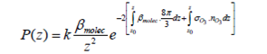
For a DIAL system, ozone number   densities nO3(z) are calculates by</font></p>     <p><font size="2" face="Verdana"><img width=323 height=45 id="Imagen 1" src="/img/revistas/rbf/v20n20/v20n20a07-image001.png"></font></p>     <p><font size="2" face="Verdana">where the contribution from aerosols   has been neglected; son and soff are the ozone   absorption cross section for wavelength</font></p>     <p><font size="2" face="Verdana">&#955;on and &#955;off respectively; aon and aoff are the   extinction coefficient for molecular scattering for the mentioned</font></p>     <p><font size="2" face="Verdana">wavelength; and Pon and Poff are the lidar   signals.</font></p>     <p><font size="2" face="Verdana">The evaluation of the   term d/dz ln [Poff(z)/Pon(z)] is an   essential element of the analysis. Generally, differentiation has the effect of   applying a high-pass &#64257;lter to a signal. In DIAL analysis this fact   represents a problem, as the signal counts P at stratospheric altitudes contain   high-wave-number noise contributions</font></p>     <p><font size="2" face="Verdana">Typically, the   altitude resolution z(zi) of ozone pro&#64257;les is   de&#64257;ned in terms of the derivative &#64257;lter. Because various   &#64257;lters are used, values of z(zi) from   different data analyses are generally not comparable.</font></p>     ]]></body>
<body><![CDATA[<p><font size="2" face="Verdana">Here we test the algorithm used in   the DIAL system of OAPA to retrieve the vertical ozone variation. To that end   we use the synthetic ozone profile measured by ozonesonde like an input to   calculate the lidar signal for then obtain the ozone profile from the DIAL   algorithm. This profile calculated is compared with the ozonesonde. The lidar   signals are calculated without noise.</font></p>     <p><font size="2" face="Verdana"><b>METHOD AND RESULTS</b></font></p>     <p><font size="2" face="Verdana">In a pure molecular atmosphere (i.e.   neglected the aerosols) the lidar signal for an altitude z of the atmosphere   and for a wavelength can be written like where   &#946;moléc is the   Rayleigh backscatter coefficient; 8p/3 is   the ratio between extinction and molecular backscatter; sO3 is the <i>Orte, et. al.</i></font></p>     <p><font size="2" face="Verdana"><img width=295 height=60 id="Imagen 2" src="/img/revistas/rbf/v20n20/v20n20a07-image002.png"></font></p>     <p><font size="2" face="Verdana">ozone cross section and nO3 is the ozone number   density. The value of 2 before the exponent indicate that the laser bin pass   through the atmosphere two times between z0   (site altitude) and z. The first term of   the exponent counts the extinction of the atmosphere due to scattering of   molecules only for a given wavelength while the second term take in account the   absorption of ozone at this emitted wavelength. To obtain the synthetic lidar   signal for &#955;on and &#955;off we need to   calculate the backscatter coefficient and the second term of the exponent for   both wavelengths. The backscatter coefficient &#946; was calculated from the density of the atmosphere using the pressure and   temperature profile measured by a sonde launched in Punta Arenas, Chile, near   of OAPA. Knowing the ozone cross section for two interest wavelengths, we can   calculate the second term of the exponent from the ozone profile measured by   the ozonesonde between 0 and 32 km as input of the DIAL algorithm. This profile   was completed with the Fortuin &amp; Kelder(1998) climatology profile.</font></p>     <p><font size="2" face="Verdana"><img width=303 height=267 id="Imagen 4" src="/img/revistas/rbf/v20n20/v20n20a07-image003.png"></font></p>     <p><font size="2" face="Verdana">
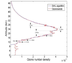
Figure 1. Comparison of both calculated ozone profile from   the DIAL algorithm in the OAPA (blue) and the synthetic ozone profile obtained   from measured by ozonesonde (red).</font></p>     <p><font size="2" face="Verdana">Figure 1 shows a comparison between the ozone profile   calculated (DIAL algorithm) and ozone profile measured by the ozonesonde which   was used as an input to calculate the lidar signals. Although the lidar signals   in &#955;on and &#955;off (308nm and 355nm respectively) was calculated without noise,   the algorithm has an intrinsic resolution. The calculate profile is like the   measured one but more smoothed. The highlighted zones show the altitudes where   the variations of ozone number density are greater. Around the 12 and 13 km   have two local peaks where the resolution (figure 2) is 0.8km. The calculated   profile follows the behavior of measured but not reaches the local maximum and   minimum of the peak. At 14 km there is other local peak but more narrow. The   resolution at this altitude is 0.8km and the wide of the peak is 0.4 km. For   this reason is probably that the calculated profile can’t “see” this layering.   Around 20 km the ozone profile measured by the sonde shows a large variation.   The measured profile presents four peaks</font></p>     <p><font size="2" face="Verdana"><img width=303 height=219 id="Imagen 5" src="/img/revistas/rbf/v20n20/v20n20a07-image004.png"></font></p>     <p><font size="2" face="Verdana">
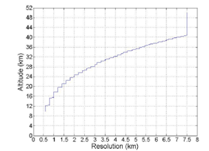
Figure 2. Vertical resolution used in the DIAL algorithm.</font></p>     ]]></body>
<body><![CDATA[<p><font size="2" face="Verdana">The calculate profile follows the ozonesonde but very   smooth. Figure 2 shows the resolution increase with the altitude and in that   altitude (around 20 km) the calculated profile doesn’t follow the thin peaks.   Around the 28 km where the resolution is of 3km, the measured profile presents   a variation similar to 12 and 13 km. We observe that the DIAL algorithm profile   don’t follow this trend due that the resolution in this altitude is greater   than the resolution at lower altitude.</font></p>     <p><font size="2" face="Verdana">CONCLUSIONS</font></p>     <p><font size="2" face="Verdana">We presented a descriptive study of a vertical ozone profile   obtained by the DIAL algorithm used in Río Gallegos. This study shows how act   the DIAL algorithm smoothing the ozone profile calculated respect of the   measured and variations in the shape of ozone profile in same layer is lost. It   is important to note that the calculated profile was obtained without noise. In   future studies we try to introduce a modeled noise to obtain lidar signals more   real.</font></p>     <p><font size="2" face="Verdana">ACKNOWLEDGMENTS</font></p>     <p><font size="2" face="Verdana">The authors would like to thank JICA (Japan International   Cooperation Agency) by financial support of UVO3 Patagonia Project; the CNRS in France for their   collaboration in facilitating the shelter and part of the electronic   instruments of DIAL.</font></p>     <p><font size="2" face="Verdana"><b>REFERENCES</b></font></p>     <!-- ref --><p><font size="2" face="Verdana">1.- Fortuin J.P.F. and H. Kelder,   1998: &quot;An ozone climatology base on ozonesonde and satellite   measurements&quot;, <i>J. Geophys. Res. </i>vol. 103, 31,709-31,734.</font>&nbsp;&nbsp;&nbsp;&nbsp;&nbsp;&nbsp;&nbsp;&nbsp;[&#160;<a href="javascript:void(0);" onclick="javascript: window.open('/scielo.php?script=sci_nlinks&ref=229189&pid=S1562-3823201200040000700001&lng=','','width=640,height=500,resizable=yes,scrollbars=1,menubar=yes,');">Links</a>&#160;]<!-- end-ref --><!-- ref --><p><font size="2" face="Verdana">2.- S. Godin, A.I. Carswell, D.P.   Donovan, H. Claude, W. Steinbrecht, I.S. McDermid, T.M. McGee, M.R. Gross, H.   Nakane, D.P. Swart, H.B. Bergwerff, O. Uchino, P. von der Gathen and R. Neuber,   Ozone differential absorption lidar algorithm intercomparison. Appl Opt, 38 (1999),   pp. 6225– 6236.</font>&nbsp;&nbsp;&nbsp;&nbsp;&nbsp;&nbsp;&nbsp;&nbsp;[&#160;<a href="javascript:void(0);" onclick="javascript: window.open('/scielo.php?script=sci_nlinks&ref=229190&pid=S1562-3823201200040000700002&lng=','','width=640,height=500,resizable=yes,scrollbars=1,menubar=yes,');">Links</a>&#160;]<!-- end-ref --><!-- ref --><p><font size="2" face="Verdana">3.- Georg Beyerle and I. Stuart   McDermid, &quot;Altitude Range Resolution of Differential Absorption Lidar   Ozone Profiles,&quot; Appl. Opt. 38, 924-927 (1999).</font><font size="2" face="Verdana"></font>&nbsp;&nbsp;&nbsp;&nbsp;&nbsp;&nbsp;&nbsp;&nbsp;[&#160;<a href="javascript:void(0);" onclick="javascript: window.open('/scielo.php?script=sci_nlinks&ref=229191&pid=S1562-3823201200040000700003&lng=','','width=640,height=500,resizable=yes,scrollbars=1,menubar=yes,');">Links</a>&#160;]<!-- end-ref --> ]]></body><back>
<ref-list>
<ref id="B1">
<label>1</label><nlm-citation citation-type="journal">
<person-group person-group-type="author">
<name>
<surname><![CDATA[Fortuin]]></surname>
<given-names><![CDATA[J.P.F.]]></given-names>
</name>
<name>
<surname><![CDATA[Kelder]]></surname>
<given-names><![CDATA[H.]]></given-names>
</name>
</person-group>
<article-title xml:lang="en"><![CDATA[An ozone climatology base on ozonesonde and satellite measurements]]></article-title>
<source><![CDATA[J. Geophys. Res.]]></source>
<year>1998</year>
<volume>103</volume>
<numero>31</numero>
<issue>31</issue>
<page-range>709-31,734</page-range></nlm-citation>
</ref>
<ref id="B2">
<label>2</label><nlm-citation citation-type="journal">
<person-group person-group-type="author">
<name>
<surname><![CDATA[Godin]]></surname>
<given-names><![CDATA[S.]]></given-names>
</name>
<name>
<surname><![CDATA[Carswell]]></surname>
<given-names><![CDATA[A.I.]]></given-names>
</name>
<name>
<surname><![CDATA[Donovan]]></surname>
<given-names><![CDATA[D.P.]]></given-names>
</name>
<name>
<surname><![CDATA[Claude]]></surname>
<given-names><![CDATA[H.]]></given-names>
</name>
<name>
<surname><![CDATA[Steinbrecht]]></surname>
<given-names><![CDATA[W.]]></given-names>
</name>
<name>
<surname><![CDATA[McDermid]]></surname>
<given-names><![CDATA[I.S.]]></given-names>
</name>
<name>
<surname><![CDATA[McGee]]></surname>
<given-names><![CDATA[T.M.]]></given-names>
</name>
<name>
<surname><![CDATA[Gross]]></surname>
<given-names><![CDATA[M.R.]]></given-names>
</name>
<name>
<surname><![CDATA[Nakane]]></surname>
<given-names><![CDATA[H.]]></given-names>
</name>
<name>
<surname><![CDATA[Swart]]></surname>
<given-names><![CDATA[D.P.]]></given-names>
</name>
<name>
<surname><![CDATA[Bergwerff]]></surname>
<given-names><![CDATA[H.B.]]></given-names>
</name>
<name>
<surname><![CDATA[Uchino]]></surname>
<given-names><![CDATA[O.]]></given-names>
</name>
<name>
<surname><![CDATA[von der Gathen]]></surname>
<given-names><![CDATA[P.]]></given-names>
</name>
<name>
<surname><![CDATA[Neuber]]></surname>
<given-names><![CDATA[R.]]></given-names>
</name>
</person-group>
<article-title xml:lang="en"><![CDATA[Ozone differential absorption lidar algorithm intercomparison]]></article-title>
<source><![CDATA[Appl Opt]]></source>
<year>1999</year>
<volume>38</volume>
<page-range>6225- 6236</page-range></nlm-citation>
</ref>
<ref id="B3">
<label>3</label><nlm-citation citation-type="journal">
<person-group person-group-type="author">
<name>
<surname><![CDATA[Beyerle]]></surname>
<given-names><![CDATA[Georg]]></given-names>
</name>
<name>
<surname><![CDATA[Stuart McDermid]]></surname>
<given-names><![CDATA[I.]]></given-names>
</name>
</person-group>
<article-title xml:lang="en"><![CDATA[Altitude Range Resolution of Differential Absorption Lidar Ozone Profiles]]></article-title>
<source><![CDATA[Appl. Opt.]]></source>
<year>1999</year>
<volume>38</volume>
<page-range>924-927</page-range></nlm-citation>
</ref>
</ref-list>
</back>
</article>
