


Services on Demand
Journal
Article
 Spanish (pdf)
 Article in xml format
 Article references
 Send this article by e-mail
Indicators
-
 Cited by SciELO
 -
 Access statistics
Related links
-
 Similars in
SciELO
Similars in
SciELO
Share

 Permalink
Revista Boliviana de Física
On-line version ISSN 1562-3823
Revista Boliviana de Física vol.20 no.20 La Paz 2012
Aerosol transport to the Andean region: A new GAW station
Andrade M., R. Mamani, F. Velarde, D. Biggeman, F. Zaratti y R. Forno
Laboratorio de Física de la Atmósfera, Instituto de Investigaciones Físicas, Universidad Mayor de San Andrés Campus Universitario, Cota-Cota, La Paz, Bolivia
Tel/Fax: +591-2-2799155, E-mail: mandrade@fiumsa.edu.bo
SUMMARY
The importance of particulate matter transport over the Andean glaciers has recently grown because new studies have suggested that at least part of the local warming at the Himalayas might be due to transport of particles to this region. In the Andean region the rapid retreat of glaciers and a moderate increase in temperature suggest that particulate matter product of biomass burning could also be playing a role in the observed glacier recession. Satellite imagery from MODIS, measurements from photometers as well as in-situ measurements were used to try to characterize some optical and chemical properties of particulate matter arriving to the Andean region. Backward trajectories and electronic microscopy were also used for this purpose. Preliminary results are reported here. In addition, the implementation of a new GAW station at Chacaltaya (5200 masl; 16°21S, 68°07W) is discussed in this context.
Key words: aerosol, aerosol transport.
INTRODUCTION
The effects of anthropogenic atmospheric aerosols upon glaciers have been object of great interest due to the observed rapid melting of the latter in different parts of the world (Hansen and Nazarenko, 2003, Hegerl et al., 2007). Studies in Asia, especially over the Himalayas (Xu et al., 2009; Lau et al., 2010) suggest that aerosols transported to this region might be playing an important role both in changing albedo properties of snow and ice as well as increasing local temperature of the atmosphere, contributing in this way to the rapid receding of the Himalayan glaciers.
Similarly, a fast decrease in area and volume of the ice mass in the Andean glaciers has been reported by different studies (Francou et al., 2003; Vuille et al., 2008). Regular field measurements at Bolivian glaciers began at the beginning of the 1990s. These measurements showed a rapid decrease of all glaciers where studies were conducted. At the moment some of these glaciers have already disappeared completely (Chacaltaya, for example). Despite some controversy about their contribution, the importance of these ice masses is directly related to the water supply of both humans and ecosystems, especially in the dry season when glaciers act as water reservoirs.
Although a positive trend in both the seasonal mean aerosol optical depth (AOD) and fire data recorded by satellite instruments has been reported between 1998 and 2005 (Koren et al., 2007), the observations showed a decline between 2006 and 2009. This decline has been linked to policy shifts (Koren et al., 2007) especially because the analysis of particular years show no especial conditions that could explain the reduction of biomass burning and its associated production of smoke (Torres et al., 2010). In contrast to this latest trend, biomass burning has been particularly intense in 2010.
REMOTE OBSERVATIONS
Observations of aerosol optical depth (AOD) using a sunphotometer CIMEL obtained at the Atmospheric Physics Laboratory, APL, (3420 masl; 16º32S, 68º04W) in the city of La Paz, Bolivia show that during biomass burning season AOD could reach unusual high values for this region (~0.80 at 340 nm; yearly mean values are on the order of 0.15). Satellite imagery from MODIS (Moderate Resolution Imaging Spectroradiometer) show that smoke produced at the Bolivian lowlands and neighbor countries can reach high altitude locations over the Bolivian Andes. Carbon monoxide measurements by the MOPITT (Measurements of Pollution in the Troposphere) sensor flying aboard NASA's Terra spacecraft show large concentrations at the surface east of the Andes and give some indication of possible transport to the high lands as well.
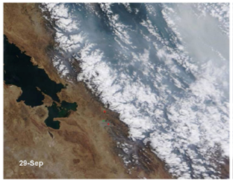
Figure 1. Smoke transported over the Andes mountains on September 29, 2010. Image obtained by a MODIS sensor onboard of NASAs Terra satellite.
IN-SITU OBSERVATIONS
With the aim of studying transport of aerosol particles produced by biomass burning east of the Andes, a set of experiments have been conducted. Using a MOUDI cascade impactor to examine surface air aerosols with different aerodynamic sizes, samples were collected under clean conditions (June, 2010) and in the middle of the biomass burning season (September, 2010) at Chacaltaya (5200 masl; 16°21S, 68°07W) and Cota-Cota, La Paz (3420 msal; 16°32'20.71"S, 68° 3'58.69"W )..
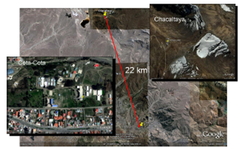
Figure 2. GoogleEarth images show the locations on the Andes mountains where samples were collected. Cota-Cota is located in the outskirts of La Paz, whereas Chacaltaya is on a relatively pristine environment. Air masses arriving from the Amazon basin, the Altiplano, and also from La Paz metropolitan region are observed at Chacaltaya..
In order to better understand the type of particles collected at high altitude locations, samples at regions near the biomass fires (522 masl; 16°16'S, 62°30W) were also collected. The analyses show a small increment in PM2.5 concentration at Chacaltaya between clean and smoky conditions. In contrast, the concentration was almost 5-times larger in regions near the fires (Table I). Analyses performed by X-Ray techniques as well as by electronic microscopy on the samples collected at stages 6 to 8, where aerodynamic size particle varies from 0.56 mm to 0.18 mm, show that under clean conditions there is no trace of potassium whereas during biomass season traces of potassium are present not only in La Paz and Chacaltaya (the Andean region) but near the area where fires are produced. The presence of potassium has been reported in aerosols from biomass burning (Andreae, 1983). More analyses are needed in order to identify other elements, size and shape of the aerosols as well as other physical and chemical properties.
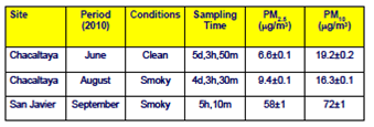
Table 1. Summary of results obtained from mass analysis.
In addition, HYSPLIT (Hybrid Single Particle Lagrangian Integrated Trajectory Model) a computer model for computing simple air parcel trajectories was used to estimate the possible sources of the air sampled at different locations by tracing its backward trajectories. As expected, the results suggest that air masses arriving at the surface or passing near the surface have their origin not far from the sampling sites, whereas air transported at higher altitudes usually travels much larger distances and could have its origin in regions completely free of influence of biomass burning.
A NEW GAW STATION
After submission of a project by a consortium of European institutions and Universidad Mayor de San Andres to the World Meteorological Organization, Chacaltaya has been designated a Global Atmosphere Watch (GAW) regional station. This high altitude station is located in a strategic place because air masses from distinct origin arrive at different times of the year. For instance, air masses from the Amazon region are typically transported from the eastern side of the continent during (Southern Hemisphere) summer time but air masses are transported from the Altiplano region during winter time.
The new station will begin taking measurements of optical properties, size distribution and other properties of aerosols arriving to this site as well as measuring concentrations of CO2, surface ozone and carbon monoxide. In addition chemical properties of aerosols will also be studied at Chacaltaya. In this case, sampling will be performed at the mountain summit (5380 masl) using a high-volume sampler.
At the same time, the recently implemented LIDAR system at the APL will be upgraded in order to study the boundary layer around or above Chacaltaya. In this case, simulations are being performed in order to optimize the system.
The new station is expected to begin regular operations by December of 2011.
CONCLUSIONS
We presented results of a preliminary study showing transport of particulate matter produced by biomass burning to the Andean region. Remote and in-stu observations show that smoke goes across the Andean mountains and is likely deposited over the glaciers present on that region. The net effects of such process will be object of study by the new GAW station at Chacaltaya.
ACKNOWLEDGMENTS
This work has been partially funded by the Danish cooperation through a project carried out by Universidad Mayor de San Andrés. We thank SwissContact Bolivia for its strong support during the field campaigns.
REFERENCES
1.- Andreae, M.O. (1983), Soot carbon and excess fine potassium: Long-range transport of 13 combustion-derived aerosols, Science, 220, 1148-1151. [ Links ]
2.- Francou, B., Vuille, P. Wagnon, J. Mendoza, and J. Sicart (2003), Tropical climate change recorded by a glacier of the central Andes during the last decades of the 20th century: Chacaltaya, Bolivia, 16°S, J. Geophys. Res., 108 (D5), 4154, doi:10.1029/2002JD002959. [ Links ]
3.- Hegerl, G.C., F. W. Zwiers, P. Braconnot, N.P. Gillett, Y. Luo, J.A. Marengo Orsini, N. Nicholls, J.E. Penner and P.A. Stott, 2007: Understanding and Attributing Climate Change. In: Climate Change 2007: The Physical Science Basis. Contribution of Working Group I to the Fourth Assessment Report of the Intergovernmental Panel on Climate Change [Solomon, S., D. Qin, M. Manning, Z. Chen, M. Marquis, K.B. Averyt, M. Tignor and H.L. Miller (eds.)]. Cambridge University Press, Cambridge, United Kingdom and New York, NY, USA.Hansen J, Nazarenko L (2004) Soot climate forcing via snow and ice albedos. Proc Natl Acad Sci USA 101:423–428. [ Links ]
4.- Koren, I., L. A. Remer, and K. Longo (2007), Reversal of trend of biomass burning in the Amazon, Geophys. Res. Lett., 34, L20404, doi:10.1029/2007GL031530.
5.- Lau ,W. K. M., Maeng-KiKim, Kyu-MyongKim and Woo- Seop Lee, Enhanced surface warming and accelerated snow melt in the Himalayas and Tibetan Plateau induced by absorbing aerosols, Environ. Res. Lett. 5, 2010.
6.- Vuille M., B. Francou, P. Wagnon, I. Juen, G. Kaser, B. Mark, and R. Bradley. Climate change and tropical andean glaciers: Past, present and future. Earth-Science Reviews, 89(3-4):79– 96, August 2008.

