


Servicios Personalizados
Revista

Articulo
 Español (pdf)
 Articulo en XML
 Referencias del artículo
 Enviar articulo por email
Indicadores
 Citado por SciELO
 Links relacionados
 Similares en
SciELO
Similares en
SciELO Compartir

 Permalink
Revista Boliviana de Física
versión On-line ISSN 1562-3823
Revista Boliviana de Física v.20 n.20 La Paz 2012
Southern Brazil: analysis of aerosols from different sources through the sensors MODIS and CALIOP
Glauber Lopes Mariano
Professor - Meteorology Department at Universidade Federal de Pelotas
Pelotas-RS, Brazil
Tel: +55 5332757321 , E-mail: glauber.mariano@ufpel.edu.br
Ericka Voss Chagas Mariano
PhD student – National Institute for Space Research – Space Geophysics Division
São José dos Campos-SP, Brazil
E-mail: erickavoss@gmail.com
Renã Moreira
Graduation student - Meteorology Department at Universidade Federal de Pelotas
Pelotas-RS, Brazil
Tel: +55 5332757321, E-mail: rena543@gmail.com
SUMMARY
Aerosols in the atmosphere directly and indirectly influence the climate of a region. However, studies related to the effects of aerosols in some areas are scarce. The southern region of Brazil is located next to major known sources of particulate matter (Brazilian savanna, Amazonia and southeastern Brazil). Thus, it has the peculiarity of having the contribution of the transport of aerosols from other sources with optical characteristics very different from each other, also with the influence of regional aerosols. This paper aims to present a project to analyze the impact of aerosols in the atmosphere over the Southern region using satellite data from Terra/Aqua (MODIS) and CALIPSO (CALIOP sensor) in the period from 2007 to 2010. With the measurements of aerosol optical depth, the atmosphere in the region will be classified into different groups. We also intend to analyze the vertical profile of aerosols and transport patterns of particulate matter from sources close to the study area, the latter with FNL data from NCEP with 1.0 ° of space resolution and time resolution of 6h. Through the preliminary results it is clear that the optical depth of aerosols in the years 2009 and 2010 reached a maximum during the winter period, probably due to fires that occur in a large part of South America
Key words: aerosol, MODIS, southern Brazil, CALIPSO
INTRODUCTION
The atmospheric aerosol consists of solid and liquid particles suspended in the atmosphere and have direct and indirect impacts on climate. The direct influence of aerosols on climate is the ability to absorb or reflect solar radiation, which depends on the chemical properties and particle size, resulting in a heating or cooling of the atmosphere. The indirect effects of aerosols refer to their ability to act as cloud condensation nuclei, changing the properties of clouds (Seinfeld and Pandis, 1998).
The southern region of Brazil, besides the aerosols emitted locally by natural and anthropogenic sources, suffers from the advection of pollutants originated at the major regions of aerosol production (e.g. the Amazon region, central and southeastern Brazil) due to the circulation present in the region (e.g. Freitas et al., 2006) (figure 1). This causes an impact on both the quantity of aerosols in the region and in the net radiation at the surface.
Some preliminary studies in the project scope using data from the MODIS sensor have shown the influence and impact of some types of aerosols in the atmosphere of southern Brazil, highlighting burning aerosols and volcanic ash resulting from the eruption of Puyehue, Chile, in June 2011.
One way to study and evaluate the impacts induced by the aerosols is to analyze its vertical distribution and impact of their presence through variables such as aerosol optical depth (AOD), in addition to the backscatter and absorption coefficients as used in a series of recent studies for the state of São Paulo (Landulfo et al., 2010, Mariano et al., 2010a and Mariano et al., 2010b).
Therefore, it is necessary to deepen the knowledge of the impacts that aerosols originating from local sources and advected from other regions in the Southern Brazil have in the local atmosphere, in order to understand its influence on solar radiation and consequent improvement of meteorological models.
METHOD AND RESULTS
MODIS sensor
The MODIS sensor is onboard the polar orbiting satellites Terra and Aqua launched in 1999 and 2002, respectively. The sensor was the first designed to obtain global observations of aerosols with moderate resolution (between 250m and 1000m depending on the wavelength used).
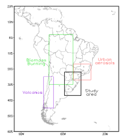
Figure 1. Aerosol type and study area
General and operational characteristics of the sensor can be found at Barnes et al. (1998). It is noteworthy that the same has 36 spectral bands between 0.4 and 14.5 µm, allowing the generation of several products related to aerosol optical depth over the ocean and land with a resolution of 10x10 km (at nadir), and to the size distribution and type of aerosol over the continent.
CALIOP sensor
The satellite Cloud-Aerosol Lidar and Infrared Pathfinder Satellite Observations (CALIPSO) has an on-board LIDAR system operating at two wavelengths (1064 and 532nm), called the Cloud-Aerosol LIDAR with Orthogonal Polarization (CALIOP). The spatial resolution of the sensor depends on the altitude – from the surface to 8.2 km the horizontal resolution is 333 m and 30 m vertically, while between 8.2 and 20.2 km is 1000 m and 60 m, horizontal and vertical resolution, respectively.
DATA AND STUDY REGION
The data used will be from MODIS (TERRA and AQUA satellites) and the CALIOP sensor (CALIPSO satellite) in the period from 2007 to 2010, to analyze the impact of different types of aerosol in the optical depth and backscatter and absorption coefficients.
The MODIS sensor data analyzed in the project consists of the product aerosol level 2 and 3, respectively MOD04 and MOD08. These two levels of data are generated globally every day, offering several properties related to aerosols such as optical depth over ocean/continent and Angstrom exponent over land. The data spatial resolution is 10x10 km (at nadir) for products of level 2 and 1.0 º for level 3.
Concerning the vertical profile of aerosols and some of its optical properties, data from the CALIOP sensor in the so called level 1B and level 2, that provide information of the perpendicular and total backscattering attenuated coefficient at 532 nm and 1064nm, and the extinction coefficient at 532 and 1064 nm and values of Lidar Ratio, will be used.
It is intended to also use the information obtained by the CALIOP sensor on the observed particle type (also called vertical mask), and aerosol subtype. To obtain the synoptic patterns that cause the transport of aerosols of known major sources such as the Amazon Region, Midwest and Southeast regions of Brazil to the Southern Region, the final analysis (FNL) of the National Centers for Environmental Prediction (NCEP) for the same period mentioned above will be used. These analyses have spatial and temporal resolutions of 1x1 degrees and 6 h, respectively, and 26 vertical levels.
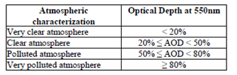
Initially, it is intended to separate, by seasons, the optical depth obtained in four different groups for the study area, as shown in Table 1. Thus, 100% refers to the maximum AOD found during the study period, in southern Brazil (black area at Figure 01).
Table 1. Characterization of the atmosphere according to the values of the maximum aerosol optical depth (2007-2010) at 550nm
RESULTS
A preliminary analysis of the aerosol optical depth in the years 2009 and 2010 for São Paulo, Pelotas, Chuí and Foz do Iguaçu can be seen in Figure 2. Note an increase of the values during the winter of the region in both years. Possibly, this increase is due to the entrance of burning plumes that occurred in central Brazil and at the Amazon. It was noticed that the maximum values found during the study period was: 1.2 (São Paulo), 3.2 (Pelotas), 2.4 (Chuí) and 4.2 (Foz do Iguaçu).
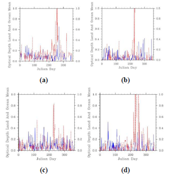
Figure 2. Aerosol optical depth at 2009 (blue) and 2010 (dashed red) to São Paulo(a), Pelotas (b), Chuí (c) and Foz do Iguaçu (d) obtained by the MODIS sensor
The reason for the apparent low value of optical depth for the city of São Paulo may have been resultant of the choice for the point of extraction of values from the MODIS sensor data. This indicates that one should choose an area representative of São Paulo and then extract the maximum value of this region.
Figure 3 shows three examples of types of aerosols over the southern region of Brazil (being better distinguished between latitudes 28° S and 35º S). It can be noted, over the study area, smoke aerosol (Figure 3a), polluted continental (Figure 3b) and dust and polluted dust (Figure 3c).
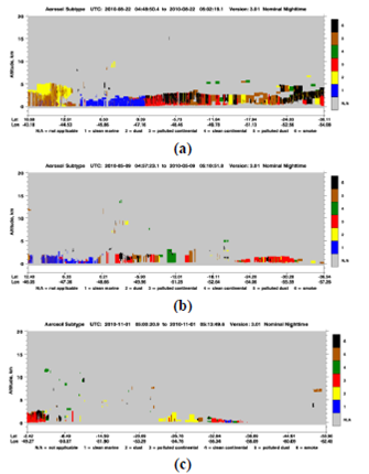
Figure 3. Aerosol Subtype by CALIOP sensor for 08/22/2010(a), 09/05/2010 (b) and 11/01/2010 (c)
CONCLUSIONS
The study area, as well as other regions that are not known large emitters of aerosol lack studies on the spatial-temporal variability of aerosols, not considering the importance of the advection of these aerosols from other regions. It is believed that this work can contribute directly to these issues, especially in the Southern region of Brazil due to the likely influence of several major known sources of aerosols: fires in the Amazon and the Brazilian savanna, anthropogenic aerosols in metropolitan areas of São Paulo, Rio de Janeiro, among others.
The information obtained may also contribute to atmospheric modeling, because of the greater understanding of aerosol- solar radiation interaction on the region, and thus provide a basis for improvement of numerical models for weather forecasts, climate and air quality.
ACKNOWLEDGMENTS
The authors would like to thank the Research Foundation of the State of Rio Grande do Sul (FAPERGS) for the approval of the project for this study. To the post-graduate program in Meteorology at the Federal University of Pelotas and the WLMLA organizing committee for their support for the participation on the event.
REFERENCES
1.- BARNES, W.L., T. S. PAGANO, E V.V. SALOMONSON. Prelaunch characteristics of the Moderate Resolution Imaging Spectroradiometer (MODIS) on EOS-AM1. IEEE Trans. Geosci. Remote Sensing, vol. 36, p. 1088–1100, 1998
FREITAS, S.R.; LONGO, K.; SILVA DIAS, M.A.; SILVA DIAS, P.L; CHATFIELD, R.; FAZENDA, A.;RODRIGUES, L.F. The Coupled aerosol and tracer transport model to the brasilian developments on the regional atmospheric modeling system: Validation using direct and remote sensing observations. Proceedings of 8 ICSHMO, Foz do Iguaçu, Brazil, April 24-28, p. 101-107, 2006.
2.- LANDULFO, E. ; LOPES, F. J. ; MARIANO, G. L. ; TORRES, A.S. ; JESUS, W.C. ; NAKAEMA, W. M. ; JORGE, M.P.P.M ; MARANI, R.L. . Study of the Properties of Aerosols and the Air Quality Index Using a Backscatter Lidar System and Aeronet Sunphotometer in the City of São Paulo, Brazil. Journal of the Air and Waste Management Association, v. 60, p. 1, 2010.
3.- MARIANO, G.L. ; LOPES, F. J. ; STEFFENS, J. ; MARTINS, M.P.P. ; LANDULFO, E. ; HELD, G. ; ANJOS, S. . Aerosols Monitoring in Rio Claro, Brazil: Using LIDAR and Air Pollution Analyzers. Optica Pura y Aplicada, v. 44, p. 55-64, 2011.
4.- MARIANO, G.L. ; LOPES, F.J.S. ; JORGE, M.P.P.M. ; LANDULFO, E. . Assessment of biomass burnings activity with the synergy of sunphotometric and LIDAR measurements in São Paulo, Brazil. Atmospheric Research (Print), v. 98, p. 486-499, 2010a.
5.- MARIANO, G.L. Efeitos das queimadas na atmosfera do estado de São Paulo – Análise de fontes próximas e distantes através de Lidar. Tese (doutorado em Meteorologia). Instituto Nacional de Pesquisas Espaciais, São José dos Campos-SP, 2010b.
6.- SEINFELD, J.H.; PANDIS, S.N. Atmospheric Chemistry and Physics: From Air Pollution to Climate Change. New York: John Wiley & Sons, Inc., 1360p. 1998.

