


Servicios Personalizados
Revista

Articulo
 Articulo en XML
 Referencias del artículo
 Enviar articulo por email
Indicadores
 Citado por SciELO
 Links relacionados
 Similares en
SciELO
Similares en
SciELO  uBio
uBio Compartir

 Permalink
Revista Boliviana de Química
versión On-line ISSN 0250-5460
Rev. Bol. Quim v.22 n.1 La Paz 2005
ARTÍCULO ORIGINAL
HEAVY METALS IN AQUATIC PLANTS AND THEIR RELATIONSHIP TO CONCENTRATIONS IN SURFACE WATER, GROUNDWATER AND SEDIMENTS - A CASE STUDY OF POOPÓ BASIN, BOLIVIA
García, M.E.,a Bundschuh, J.,b Ramos O.,a Quintanilla J.,a Persson, K.M.,c Bengtsson, L.,c and Berndtsson', R. ,c
a Instituto de Investigaciones Químicas de la Universidad Mayor de San Andrés, La Paz —Bolivia
b International Technical Co-operation Programme CIM (GTZ/BA), Frankfurt, Germany
c Instituto Costarricense de Electricidad ICE, San José, Costa Rica
Department of Water Resources Lund University, Sweden
ABSTRACT
The uptake of the heavy metals Cd, Zn, Pb, As, and Fe by aquatic plants — thereby entering the human food chain — was studied in the Poopó basin, located in the semiarid, central Andean highland of Bolivia. At twenty sites around Poopó and Uru-Uru lakes, samples of aquatic plants, sediments, surface water and groundwater were taken. The spatial distribution of heavy metals indicate that most of the Cd and Pb influx into the semiarid Poopó basin results from mining activities and subordinate from geothermal activities, which are both located in the NE of Poopó basin. Also, arsenic concentrations are of similar magnitudes, released from mining activities and natural weathering of As-bearing rocks and predominantly observed in the W, SE, and S of Poopó basin.
In the aquatic plants, concentrations of Cd, Zn, Pb and As were found in the ranges 0.0–45.0, 0–197, 0–858, and 83–943 mg/kg, respectively. The heavy metal concentrations found in aqueous plants are correlated to varying extents to the corresponding heavy metal concentrations in sediments, surface water and groundwater. High Cd and Pb concentration in aquatic plants sampled within Poopó Lake (15–23 and 858–936 mg/kg, respectively) correlate strongly with high Cd and Pb concentrations of its alkaline water (1.37–1.51 and 0.36–0.38 mg/L, respectively) as well as with high Cd and Pb concentrations in the lake sediments (20–25 and 210–260 mg/kg, respectively). However, at other sampling sites of the basin this correlation of Cd does not always exist. For As and Zn, no correlation could be found between the respective concentrations in aquatic plants, sediments, surface water and groundwater.
There is no correlation between Cd, Zn, and Pb concentrations in surface water and groundwater. This shows that these heavy metals are predominantly fixed in the sediments and taken up by plants and/or transported as sediment load to Poopó Lake (Cd, Zn, and Pb cations are only stable in larger amounts under acidic conditions, e.g. in the acidic rivers influenced by mining activities, and nearby groundwater bodies, which are found in the NE of Poopó basin). In contrast the anions of arsenic are more soluble in surface water and groundwater with a neutral or slightly alkaline pH.
Keywords: Poopó basin, heavy metals, aquatic plants, groundwater, surface water, sediments, anthropogenic contamination, natural contamination
INTRODUCTION
Heavy metal uptake by land and aquatic plants from sediments, which are either anthropogenicaly contaminated or naturally rich in heavy metals, is a problem in many parts of the world, particularly in mining or industrial areas. In the Poopó basin, which comprises the lakes Poopó and Uru-Uru (Figs. 1 and 2) and is located in the central Andean highland of Bolivia, mining activities and natural weathering of rocks has resulted in several sites containing large quantities of heavy metals in both river and lake sediments. These sediments are, in turn, a source of uptake by aquatic plants. The purpose of the present study is to determine the heavy metal concentrations of aquatic plants in the Poopó basin as a function of the corresponding heavy metal concentrations in surface water and sediments.

Study Area
The Basin of the Poopó Lake is located in the central Bolivian highland (3600-4000 m a.s.l.) (Fig. 1), and is bordered to the west and east by the mountain chains of the western and eastern Cordillera (Montes de Oca, 1997).
The study area of the Poopó basin is part of a larger system of basins, which comprise, from north to south, the basins of Lake Titicaca, Desaguadero River, Poopó Lake and the Coipasa y Uyuni salt pans. This system of basins is filled by Quaternary deposits of glacial, fluvial, eolic and lacustrine origin.
Due to the rich deposits of metal ores, in the northern and eastern parts of Poopó basin and the nearby areas, mining activities started over 1000 years ago. However, the mining activities did not consider potential environmental damage, and so sediments, soils and water became increasingly contaminated, especially by heavy metals, but also by cyanides, and other contaminants. Release of untreated residual water from ore processing (operating mines), as well as lixiviation of sludges or solid waste deposits by rain water (from both current and former mining activities) are the most important contamination sources. Such water is rich in heavy metals (predominantly Pb, As, Cd, Fe, Zn), which are either present in dissolved form or bound on suspended loads or colloids. Additionally they contain — if cyanides are used for ore dressing — high concentrations of cyanide, and — if acids are used for digestion of the ores — they are very acidic, which results in a high solubility of heavy metals. The most important areas with mining activities are in the northern part of Poopó basin (mining area of Oruro, which has a complex geological structure and comprises polymetalic minerals, such as Sn-Ag (BGS, 1985), encased by dacits, and Palaeozoic sediments), and in the eastern part of Poopó basin (Fig. 2).
During the presence of the Quaternary glacier, the lacustrine, fluvial and eolic processes formed the main parts of current sediments. The lacustrine deposits that correspond to the interglacial lake development cover the greater part of the basin. The main industrial minerals in the area are found on on calcareous scabs and salt scabs, formed during the recent lacustrine processes. To a lesser extent, sulphur salts (sulphur diapires, e.g. in the east of Oruro (Fig. 2) are found.
The soil in the region is saline and the salinity levels increase from north to south. The sediment and salts are transported from the Desaguadero river located to the north of the Poopó Lake in a southern direction and they are deposited in Poopó Lake, increasing the salinity of the lake water to approximately 25 g/L. Due to the very small topographic gradient, small amounts of deposited sediments, as well as increased water flows, results frequently in significant increases of the lake area and the formation of lagoons, which endangers communication by road.
In the superbasin composed by the basins of Lake Titicaca, Desaguadero River, Poopó lake and the Coipasa y Uyuni salt pans, hydrogeology is characterised by a sequence of groundwater reservoirs, which are recharged in the mountainous areas and the slopes of the western and eastern cordillera (Fig. 1) and which discharge in the direction of the Titicaca Lake, the Desaguardero River, the Poopó Lake and the Coipasa and Uyuni salt pans. In general, it can be found that the aquifers discharging towards Lake Titicaca present better hydrogeological conditions and that they contain — compared with the southern part, where the Poopó basin project is situated — large and important volumes of groundwater with a good chemical quality.
In respect to the project area of Poopó basin, it can be recognized that in the northern Poopó and Uru Uru lakes area, important groundwater reservoirs are located (Fig. 2). Towards the south, the region receives much less precipitation and as consequence some of the rivers are dry during most of the year and carry water only in short periods related to sporadic rains. This water quickly infiltrates underground, making groundwater the only water resource in most parts of this region. The dryness of this area, together with the absence of suitable surface water for drinking purposes and the limited groundwater resources put pressure on human life, and for this reason, the southern part of Poopó basin is practically uninhabited.
The groundwater of Poopó basin is — in contrast to most of the surface water — in general, of good quality: it is clear, colourless, has a low electrical conductivity and much lower concentrations of heavy metals compared to surface water. However, as a result of increasing anthropogenic contamination (heavy metals from mining activities and inlets from household sewage), the quality of the groundwater is decreasing continuously with time. The groundwater resources represent a very important resource, especially in the southern areas around the Poopó Lake, where rainfall is low compared to the northern part, and, thus, where low mineralized surface water is extremely limited.
The vegetation of the semiarid Andean highland predominantly consists of xerophyte species, which are typical of this region. The high levels of salt in the soils and the water allow solely the presence of a salt-resistant vegetation cover including very low grasses, such as Distichlis humilis and Muhlenbergia fastigiata (Montes de Oca, 1997). Another typical vegetation is the heaths of "Thola", and the “Totora” (Schoenoplectus californicus var. tatora). Pasture animals (e.g. goats and sheeps), as well as strong winds and the formation of sand dunes affect the vegetation and its growth negatively.
Sampling and Analysis
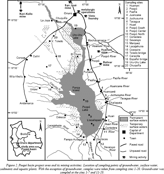
Samples from surface water, sediments, and aquatic plants were taken at 20 sites from the Poopó and Uru-Uru lakes and the rivers discharging into these lakes (Sampling sites 1-20; Fig. 2). Additionally, groundwater samples were taken at 17 sampling points of the basin in 8 excavated wells and 9 drilled wells with different depths (1.5-60 meters) – the same sampling sites as sediment samples, with exception of sites 8-10.
The sampling was performed during the two dry periods (between May and September), and during two rainy periods (between January and March), all in all covering two years. Water and groundwater samples were collected and filtered through a standard 0.45-μm-pore filter and filled into two Nansen plastic bottles, one for physical-chemical analysis and the second, which was acidified using nitric acid for heavy metal analysis (cadmium, zinc, lead, iron, and arsenic).
At each sampling site 1-20 (Fig. 2), one kilogram of superficial sediment (depth 0-10 cm) was collected and filled into polypropylene bags. A dredge was used to get sediment samples from the lake (sampling points 8-10). In the laboratory the samples were dried and digested by adding acid.
At the same sampling sites about 1 kg aquatic plants (predominantly Myriophyllum sp., Potamogeton sp., Schoenoplectus tatora sp. (Totora) and Bacharis Juncea sp.) were collected and filled in polypropylene bags. The plants were dried and acid digestion was applied.
The heavy metals of the samples (Pb, As, Cd, Fe, Zn) were analysed according to EPA standard methods, using an atomic absorption spectrophotometer and a Perkin Elmer Analyst 300 graphite oven. The sediment and plant samples were previously digested by adding acid to extract the metals. The detection limits were 10 ng/mL for Pb, 200 ng/mL for As, 0.4 ng/mL for Cd, 5 ng/mL for Fe, and 0.5 ng/mL for Zn.
RESULTS AND DISCUSSION
The analysis data of heavy metals in aquatic plants, sediments, surface and groundwater obtained from the 20 sampling sites (Table 1) indicate that the environment of Poopó basin is significantly affected by anthropogenic (mining activities) and, to a lesser degree, by natural (dissolution of rocks) contamination. Most affected are the aquatic plants, the surface water, and the sediments, the groundwater being affected to a smaller extent. The respective processes of heavy metal enrichment in the different components are additionally strengthened by the semiarid climate and the flat topography, which favors the enrichment of the heavy metals especially in the Uru-Uru and Poopó lake areas.

In the following tables, the concentrations the heavy metals (Pb, As, Cd, Fe, Zn) are given for aquatic plants and then the relationship between heavy metal contents in aquatic plants and those of the sediments, surface water, and groundwater is discussed for two groups of sampling sites, those affected and those not affected by mining activities.
Figure 3 shows the concentrations of heavy metals in aquatic plants obtained from the sampling sites 1–20 (Fig. 2). In order to visualise the correlation with heavy metal concentrations in sediments, surface water, and groundwater, the respective heavy metal concentrations in these components are additionally plotted. Figure 3 indicates, that the concentrations of Cd, Zn, and As are of the same magnitude in aquatic plants and in the sediments (indicating good correlation between them), whereas those of Pb and Fe show moderate differences (resulting in a moderate correlation). The heavy metal concentrations of surface water are much lower, and those of groundwater even less – and a correlation with the respective heavy metal concentrations in aquatic plants is not clearly visible.

Cadmium: The highest concentrations of cadmium in aquatic plants were observed in the northeast, near the region having high mining activity (at sampling points 2 and 3: Pazña river, which isacidic; and is influenced by mining activities, and the Poopó river, which hasalkaline water and is partly fed by geothermal water, where Cd concentrations in aquatic plants are 45 and 18 mg/kg. The latter shows also the highest Cd content recorded in a sediment sample: 75 mg/kg). Surface water show mostly values of < 0.1 mg/L in the S and SE of Poopó basin, where no influence of mining activities exists (sampling points 4–13) and values between 0.1 and 0.2 mg/L in the W and N of Poopó basin (sampling points 13–20). The water, which is transported by the rivers into Poopó lake and the respective sediment load causes an enrichment of Cd in Poopó Lake, reaching high values of 15–23 mg/kg, 20–25 mg/kg, and 1.4–1.5 mg/L of cadmium in aquatic plants, sediments and lake water (sampling points 8–10). In groundwater, the highest Cd concentration was 0.23 mg/L (sampling point 11), all other sampling points showed concentrations of < 0.08 mg/L, values below the permissible limit according to the Bolivian laws (RMCH, 1995).
Zinc: When comparing the Zn concentrations in aquatic plants with the Zn concentrations in surface water, groundwater and sediments, no correlation can be obtained. In respect to surface water and groundwater, the Zn concentration is similar in most of Poopó basin. So in the sampling points 5–20, which cover the Poopó basin with exception of its northeastern part, the Zn concentration ranges are 0.03 –0.2 mg/L in surface water and 0.00–0.02 mg/L. In the NE of Poopó basin increased values 0.6–5.8 mg/L and 0.00–4.2 mg/L are found for surface water and groundwater, respectively. It must be remarked, that the Zn concentration of Poopó Lake –in contrast to Cd– does not show evaluated values. Also the sediments of the sampling sites 5–20, which include also the Poopó lake sediments, show uniform Zn concentrations (35–220 mg/kg). Elevated Zn concentrations are only found in the NE of Poopó basin (sampling sites 1–4), which is influenced by discharges of liquids from mining activities (acid pH in sampling sites 1 and 3 (Huanuni and Pazña rivers): pH = 2.6 and 4.3, respectively) and inflow of alkaline geothermal water into the respective rivers (sampling site 2; pH = 9.4). Due to the low pH-values in sampling sites of the Huanuni and Pazña rivers, here the Zn concentration is highest in the surface water (5.6 and 5.8 mg/L, respectively) and in the groundwater (2.2 and 4.2 mg/L, respectively). Whereas the sediments of Huanuni show no elevated Zn concentrations, those of Pazña River are 525 mg/kg. The highest Zn concentrations in sediments are those of Poopó River (1700 mg/kg), which may be caused by the high pH-values of the river water, which result in precipitation of dissolved Zn, hence increasing the Zn concentration in the sediment.
Lead: The lead in the Poopó region comes from mining activities, the air contamination by dusts from the foundries and the weathering of Pb-bearing rocks. So the S and W of Poopó basin, which are not affected by the mining activities (sampling sites 11–19), show low Pb concentrations in aquatic plants (0.00 mg/kg with the exception of site 17, which has 82 mg/kg), sediments (25–90 mg/kg), surface water (0.03–0.04 mg/L), and groundwater (0.02–0.08 mg/L). In the NW of Poopó basin, which is influenced by mining activities, as well as in Poopó Lake, the discharge area of all these Pb-rich surface water from the NW and their sediment freight, the highest Pb concentrations are found. So Poopó Lake shows the highest Pb concentrations in aquatic plants (858–936 mg/kg), which correspond to high Pb concentrations in the surface water (210–260 mg/kg). Nevertheless the highest Pb concentration in sediments was found in the alkaline Poopó River (4430 mg/kg), which, however, results only in 73 mg/kg of Pb in aquatic plants.
Arsenic: Compared to Cd, Zn, and Pb, the distribution of arsenic is much more uniform. Regarding the aquatic plants, again the W and S of Poopó basin (sampling points 11–19) show lower values (83–280 mg/kg), whereas the NE of Poopó basis with its influence by mining activities and the Poopó Lake itself shows something higher values (210–940 mg/kg), whereas the As-concentrations in the sediment are similar (280–71; exception Poopó River with 1485 mg/kg). In contrast to Cd, Zn, and Pb, where the origin is predominantly in the NE of Poopó basin with its mining activities, significant input of As into Poopó Lake comes from natural sources (As-bearing rocks) from the W, SE, and S (surface water 0.09–0.14 mg/L; groundwater 0.01–0.09 mg/L).
Iron: The iron concentration in aquatic plants and sediments do not show spatial trends, which indicates that both, mining activities and weathering of Fe-bearing minerals contribute to a similar degree to the Fe present in the environment of Poopó basin. In surface water the Fe concentrations are low (0.01–0.1 mg/L), the only exceptions being the acidic water of the rivers Huanuni and Pazña, with 0.5 and 2.2 mg/L, respectively. The same can be found in groundwater, with low Fe concentrations in the range of 0.00–0.06 mg/L, throughout the Poopó basin —with exception of Huanuni and Pazña sampling points, where groundwater iron reaches 0.4 and 1.1 mg/L, respectively.
Summary: For the most part, the Cd and Pb influx into Poopó basin results primarily from mining activities and secondarily from geothermal activities, making the NE of the basin the principal source of Cd and Pb. Also, arsenic releases from mining activities and by weathering of As-bearing rocks (predominantly in the W, SE, and S of Poopó basin) are of similar magnitudes. The same is valid for iron. However, further studies are required to determine quantitatively the corresponding influxes for the distinct heavy metals into Poopó basin.
The concentrations of Cd, Zn, Pb, As and Fe found in aqueous plants are, to very different extents, correlated to the corresponding heavy metal concentrations in sediments, surface water and groundwater (Fig. 4). High Cd and Pb concentrations in aquatic plants within Poopó Lake correlate positively with high Cd and Pb concentrations of its alkaline water as well as high Cd concentrations in the lake sediments. However at other sampling sites this correlation of Cd does not always exist. No correlation of As and Zn concentrations in aquatic plants and As and Zn contents of sediments, surface water and groundwater can be found.

In general, no correlation of heavy metal concentrations in surface water and groundwater can be found. This indicates that the heavy metals are fixed in the sediments and taken up by plants and/or transported as sediment load to Poopó Lake during the rainy season.
The predominantly alkaline characteristics of the Poopó basin has prevented large anthropogenic contamination from heavy metals dissolved in the surface and groundwater, and most of the heavy metals are absorbed or bound in other forms to the sediments. This becomes especially valid for cations of Cd and Pb, which are only present in dissolved form under acidic conditions, whereas anions of arsenic are more soluble in the surface water and groundwater with a neutral or slightly alkaline pH.
REFERENCES
BGS -British Geological Service, Geobol, “El Precámbrico en Bolivia”, La Paz, 1985.
Montes de Oca Ismael, “Geografía y Recursos Naturales de Bolivia”, 3rd edition, 1997.
RMCH -Reglamento en Materia de Contaminación Hídrica de la Ley del Medio Ambiente No. 1333, La Paz, Bolivia,1995. [ Links ]
Risacher F., Fritz B., Bromine geochemistry of Salar de Uyuni and deeper salt crusts, Central Altiplano, Bolivia. (2000) Chemical Geology, 167, 373-392.

